
Aalborg is a city located in the northern part of Denmark with approximately 135.000 inhabitants, covering an area of 111 km2. *1 The climate in the nothern part of Denmark is characterized by cool summers and mild winters and an yearly precipitation between 600 and 750 mm *2. The Aalborg case focuses on Kærby, mainly a residential area, and Håndværkerkvarteret, an industrial area, south of central Aalborg.
The interaction between streams, drainage system, groundwater, and variability in rainfall is examined using Kærby and the Håndværkerkvarteret as two linked case studies. Even though both study sites are heavily influenced by each other, different conditions causes urban flooding in each area. High groundwater table, low elevation level, and the fact that Kærby is enclosed by two streams, makes Kærby an ideal case-study for studying the effects of integrating the complete hydrological cycle in respect to urban flood forecasting. Håndværkerkvarteret consists of mostly impermeable concrete with a few open grass areas. As such the urban flooding is more likely linked to the hydraulic capactity of the outgoing streams.
| Kærby | Håndværkerkvarteret | |
|---|---|---|
| Total area | 60 ha | 38 ha |
| Impervious area | 40 % | 88 % |
| Inhabitants | 2100 | ~80 |
The terrain varies from a height of ? to 0 meters at sea level in Limfjorden. Kærby and Håndværkerkvarteret are located in a low point between to higher points to the east and west. Interactive visualization of DEM of Østerå catchment with a resolution of 10x10 meters. The vertical height is excagerated by a factor of 10. Click on the image beneath to try it out!
It is believed that different conditions in weather, soil characteristics (both saturated and unsaturated zone), sewage system capacity, and hydraulic stream network capacity are the main causes of urban flooding in both areas. However both drainage systems discharge to the Østerå stream network, and the capacity of this network is observed to be limiting during storm weather events. (Sources!) However each location has its unique problems listed below:
Kærby:
Håndværkerkvarteret
(precipitation, groundwater level, soil-water saturation level, sewage capacity, hydraulic capacity of stream network)
In both Kærby and Håndværkerkvarteret the urban hydrological system is monitored through a campaign. The goal of this data campaign is to identify the conditions that causes flooding in both areas and to provide the necessary in- and output data in order to validate the hydrological models. A local experimental setup is developed to inquire knowledge of stream water level and flow, groundwater level, and overflow discharge from the sewer system. The data transmission system is automated using GSM modules sending data feedback to an FTP server once a day. Later on this automated data logging system will be used for real-time hydrological flood modeling and forecasting with much higher frequencies of data transmission. Rainfall is measured using ecisting local rain gauges and indriectly measured using two x-band and one c-band radars.
The experimental setup consists of 6 stream water level gauges, 3 groundwater level observation drillings, 3 overflow discharge registrations, and 3 pump discharges (on/off and volume estimate), see Figure 3.
The danish rain gauge network, see Figure 1, covers the topographic cathcment with 7 rain gauges with historical data back to the late 1990's. Approximately 1.7 km from the project area is a parking lot equipped with a disdrometer and 9 tipping bucket rain gauges with real-time data transmission and historical data back to 2006(CROSSCHECK!). See http://vejrradar.dk/beware/ for real-time data.
Two x-band and one c-band radars are available for radar imaging of precipitation of the project area. The individual coverages are visible in Figure 4.
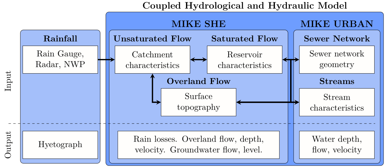
A preliminary model is setup, wherein a coupled hydrological and hydraulic model is developed. The hydrological model is a national model of the freshwater cycle in Denmark built in the MIKE SHE environment, also known as the DK-model (Henriksen et al., 2003). The hydraulic model is a local drainage model built in MIKE URBAN. The following processes are included: overland flow, evapotranspiration, unsaturated flow, saturated flow, stream flow, and sewer flow. See Figure 3 for the model setup.
A global sensitivity analysis (GSA) is applied to the preliminary model based on covariance sensitivity indices. The sensitivity indices are based on flood-relevant output, such as flood depth and extent. It is expected that the sensitivity indices reveal the most influential model input parameters and key hydrological processes. The preliminary model setup is simplified in the Hindcast Setup based on the sensitivity from the GSA.
A hindcast setup of the preliminary model for the complete hydrological cycle is developed and calibrated using historical data. Selected previously flood events from historical data are simulated and cataloged with the purpose of deriving the risk of floods dependency on the input parameter, e.g. rain intensity, soil moisture in top layers, base flow in streams, groundwater level. Hindcasting experiments including perfect forecasts with different lead times and different temporal and spatial resolutions. The model complexity is reduced by simplifying the less important hydrological processes. The simplified processes are calibrated and validated against the complex models and observation data collected during the preliminary research and are used in the Real-time Setup
A real-time setup of the urban flood forecast model developed by using the simplified physical models. Varying model setups are performed to evaluate different model complexities. This project does not deal with improving rainfall forecast methods, but instead uses available forecasts methods, such as the nowcast method developed by Aalborg University (Thorndahl et al., 2009). The numerical weather data is chosen from the HIRLAM model (High-Resolution Limited Area Model, hirlam.org) or similar weather predictions from new developments from TUD. Radar and numerical weather model data are used to forecast rainfall with different lead times.
2D overland flow models are in several studies evaluated to be impractical for real-time forecasting due to long computational time, eg. (Leitão et al., 2013; Boonya-Aroonnet et al., 2007). Therefore a 1D overland flow model is developed for Kærby. In respect to overall model setup and development own programmed software and modifications to commercial packages behavior are made. An operational real-time flood forecasting model is tested for real life scenarios with live data if possible. The uncertainty of model output is scrutinized in order to evaluate a platform for the end-users to make informed decisions.
Results from the flood models in respect to spatial and temporal resolution, forecast lead times, forecast methods, computational time, storm severity, and flood model setup are analyzed. The forecast performance is quantified by its ability to predict flood events related to the end-user needs. End-user requirements such as purpose, value, and reliability are investigated for the flood forecast system.
This project will contribute with new methods to the current state of the art urban flood forecast modeling and bring significant knowledge about the interaction between the hydrological processes and how they affect urban flooding. The predictability, uncertainty, and reliability of a new developed integrated urban flood model are examined and scrutinized in order to evaluate the urban flood models usefulness in practice for the end-users.
References used on this page:
*1 http://apps.aalborgkommune.dk/statistik/webaarbog/aarbog12/struktur/Areal/indexlevel1/ArealAreal.html
*2 http://www.klimatilpasning.dk/viden-om/klima/klimaaendringeridanmark/aendringer-i-nedboer/nedboeren-i-danmark-fra-1874-til-i-dag.aspx